Baikal has an elongated crescent shape. Its extreme points lie between 51°29" (Murino station) and 55°46" (the mouth of the Kichera River) northern latitude and between 103°44" (Kultuk station) and 109°51" (Dagarskaya Bay) eastern longitude.
The shortest line running across the area of the lake and connecting the most distant points of its shores, i.e. the length of the lake is 636 km, the greatest width of Baikal, equal to 79.4 km, is located between Ust-Barguzin and Ongureny; the smallest, different 25 km, is located opposite the river delta. Selenga.
The area from which rivers currently collect water and bring it into Baikal, or its so-called catchment area, is 557,000 square meters. km *) . It is distributed very unevenly relative to the area of the lake itself (see map of the basin). Along the entire western shore, the border of this area runs just a few kilometers from the shore of the lake. It is bordered almost everywhere by the watershed of the mountains visible from the lake.
*) According to Yu.M. Shokalsky, the Lake Baikal basin reaches 582,570 sq. km. - Approx. ed.
The Lena River basin comes directly to this watershed throughout northern Baikal, and the Lena itself originates 7 km from the shore of Baikal near Cape Pokoiniki. The greatest distribution of the Baikal catchment area is to the south and southwest of the lake towards the Selenga River basin. The basin of this river, equal to 464,940 square meters. km, is 83.4% of the total drainage area Baikal. The next largest basin is the Barguzin River, whose basin is 20,025 square meters. km and accounts for 3.5% of the total catchment area of Lake Baikal. All other tributaries of Lake Baikal account for a drainage area of 72,035 square meters. km, equal to 13.1% of the total drainage area of the lake.
Lake Baikal itself is located in a narrow basin, bordered by mountain ranges, spurs of the Sayan Mountains, cut in a number of places by relatively narrow valleys through which its tributaries flow into the lake.
In the south, along its eastern banks, stretch almost all year round snow-covered peaks of the Khamar-Daban ridge with the highest altitudes up to 2000 m above sea level. This is exactly the chain of mountains that is visible to anyone driving along the shores of Lake Baikal along railway. These mountains are especially clearly visible on the stretch between the station. Baikal and Art. Kultuk. The Pribaikalsky ridge adjoins the western shores of southern Baikal. Its height along almost the entire length from Kultuk to the Small Sea does not exceed 1300-1200 m above sea level, but these mountains stand on the very shore of Lake Baikal.
Starting from the Small Sea and to the northernmost tip of the western shores of Baikal, the Baikal mountain range stretches, gradually rising north from Cape Ryty to Cape Kotelnikovsky. In this section, Mount Karpinsky reaches greatest height at 2176 m, Mount Sinaya - 2168 m, etc. Almost along the entire length of the peaks of the Baikal ridge are covered with snow that does not melt even in summer, and in many places traces of glaciers that recently descended from them are visible.
This ridge is crossed by a number of deeply incised valleys along which mountain streams stretch. In terms of its picturesqueness, the eastern shores of the northern part of the lake are one of the most wonderful places on Lake Baikal. To the eastern shores, starting from the Chivyrkuisky Bay and to the northernmost tip of the lake, another ridge approaches - the Barguzinsky, reaching a significant height - up to 2700 m. This ridge, however, is located at some distance from the shores, and the latter are directly adjacent to relatively low foothills, in some places forming picturesque cliffs, and on the predominant part of the shore, gently sloping down to the waters of the lake.
The interval of the eastern shore of the lake between Selenga and the Barguzin Bay is bordered by the Ulan-Burgasy ridge, which has a height of 1400-1500 m near Lake Baikal.
The most pronounced bend of the Baikal coastline is the Svyatoy Nos Peninsula, located between the two largest bays on Lake Baikal - Barguzinsky and Chivyrkuisky.
This peninsula in the form of a massive block of stone, reaching a height of 1684 m, rises above Lake Baikal, falling down to the water with steep rocky cliffs. However, towards the mainland it decreases more gently and then turns into a narrow and swampy isthmus, merging with the vast lowland adjacent to the river valley. Barguzin. There is no doubt that even recently the Svyatoy Nos Peninsula was an island, and the waters of the Chivyrkuisky and Barguzinsky bays formed one vast strait, subsequently filled with the river’s outflows. Barguzin.
There are 19 permanent islands on Lake Baikal, the largest of which is Olkhon. It has a length of 71.7 km and an area of 729.4 sq. km. Olkhon Island, separated from the continent by a strait less than a kilometer wide, called the “Olkhon Gate”, elongated in a north-east direction, is a mountain range, with the highest point - Mount Izhimei, reaching a height of 1300 m and steeply plunging to the east shore. The northern part of the island is wooded, and the southern part is completely devoid of woody vegetation and is covered with meadows with traces of the steppe vegetation that was apparently once widespread here.
The shores of Olkhon facing the Small Sea are subject to very strong destruction by the surf. The group of Ushkany Islands, located opposite the Svyatoy Nos Peninsula in the middle part of the lake, is interesting both in its position and in its picturesqueness. This group consists of four islands, of which Bolshoi Ushkany Island has an area of 9.41 square meters. km, and the other three islands (Thin, Round and Long) do not exceed half a square kilometer. The Big Ushkany Island reaches a height of 150 m, and the small ones are only a few meters above the average water level of Lake Baikal. All of them are rocky, with shores composed mainly of limestone and covered with dense forest. These islands are greatly destroyed and seem to be cut off by the surf.
The time is not far when the small Ushkany islands will disappear under the surface of the waters of Lake Baikal.
The remaining islands on Lake Baikal are all located near its shores, four of them are in the Chivyrkuisky Bay (Bol. and Mal. Kyltygei, Elena and Baklaniy), six in the Small Sea (Khubyn, Zamugoy, Toinik, Ugungoy, Kharansa, Izokhoy, etc.) and the rest - in close proximity to the shores of other parts of Lake Baikal, such as Listvenichny, Boguchansky, Baklaniy (near Peschanaya Bay), etc.
All islands have a total area of 742.22 square meters. km, and most of them are large capes, separated from the continent under the influence of the destructive force of the surf. In addition, there are also several low sandy islands on Lake Baikal, which are completely hidden under water in high water and protrude above the surface only when the waters are low. These are the islands, elongated in the form of narrow strips, separating Proval Bay from Baikal (Chayachy Islands, Sakhalin), and these are the islands separating the Angarsky Sor from open Baikal - the so-called Yarki. The islands that separate Istoksky Sor from open Baikal also belong to the same type.
Bays and bays, so important for the settling of small ships, are a relatively rare phenomenon on Lake Baikal, and moreover, they are distributed very unevenly along the coast.
The largest bays, Chivyrkuisky and Barguzinsky, which we have already mentioned above, are formed by the Svyatoy Nos peninsula protruding from the lake. Almost a gulf is the so-called Small Sea, separated from open Baikal by the island of Olkhon and Proval Bay, north of the Selenga delta.
Peschanaya and Babushka bays on the western shore of southern Baikal are famous for their picturesqueness. Further, a unique group of bays, or rather lagoons, called “sorov” on Baikal, are its former bays separated from the open lake by narrow sandy spits. These are the Posolsky and Istoksky soras, separated from Lake Baikal by narrow strips of land washed up by the action of the surf, such is the Angarsky sor in the very north and Rangatui in the depths of the Chivyrkuisky Bay. All of them are separated from Baikal by narrow strips of sediment, in the form of sand spits, sometimes completely hidden under the surface of the lake in high water.
Apart from these large bays, almost separated from Lake Baikal by its sediments, then all other bends of its coast largely depend on the direction of the Baikal coastline, since the tortuosity of its coast depends on whether the coast is directed along or across the dominant direction of the mountain ranges composing the shores.
Those sections of the shore of Lake Baikal that are directed across the main direction of the mountain ranges that limit its basin are characterized by significant ruggedness, such as the Olkhon Gate or the southern shore of the Barguzin Bay. The same sections of the coast, which in their direction coincide with the direction of the mountain ranges limiting the Baikal basin in this area, are characterized, on the contrary, by exceptional straightness, broken only by secondary accumulations of coastal sediments or the eroding action of the surf. This is the entire section of the western shore of Lake Baikal from the mouth of the river. Sarma to Cape Kotelnikovsky, this is the area that borders the Svyatoy Nos Peninsula from the west, and many others.
In many areas, the shore of Lake Baikal is completely straight for many kilometers, and very often almost sheer cliffs, many meters high, drop into the water. Particularly characteristic in this regard is the area between Sosnovka and the entrance to Chivyrkuisky Bay on the eastern shore of middle Baikal or the area from Onguren to Cape Kocherikovsky on the western shore of middle Baikal.
Based on the depth distribution or bottom topography, Baikal can be divided into three main deep depressions. The first of them is the southern one, occupies the entire southern Baikal to the confluence of the river. Selenga. The greatest depth of this depression is 1473 m, the average depth is 810 m. The depression of southern Baikal is characterized by an exceptionally steep bottom slope near the western and southwestern shores and a relatively gentle slope on the opposite slopes.
Lake sediments at the bottom of the southern depression have not completely smoothed out the features of the original relief, at the bottom of which there is a series of hollows and irregularities adjacent to the Transbaikal coast and elongated in the northeast direction. These underwater ridges are especially pronounced in the part of the depression adjacent to the river delta. Selenga, and are hidden under its sediments. One of these ridges protrudes so significantly that it forms in the middle of the width of Lake Baikal on the line between the village. Goloustny and s. Posolsky shallow water, where depths of 94 m were discovered, and the depths in this shallow water have not yet been sufficiently explored and one cannot guarantee that even shallower depths will not be found there. This shallow water is, in all likelihood, the remnant of Stolbovoy Island, marked here on ancient maps, partly destroyed by the waters of Lake Baikal, partly sank below its surface.

On the bridge separating the southern deep depression of Lake Baikal from its middle depression, the depth does not exceed 428 m, and this bridge basically reflects the structure of the bedrock. This view is supported by the presence of a longitudinal ridge extending in front of the Selenga delta, extending far in both the southwestern and northeastern directions and known among local residents as “manes.” In its part adjacent to the Selenga, this bridge is gradually significantly modified by the Selenga outfalls.
To the east of the mane directed to the northeast, approximately opposite the channel of the Selenga delta, called Kolpinnaya, there is a bottom depression reaching 400 m and locally called the “abyss”. A legend is associated with this abyss that in this place in the bottom of Baikal there is a hole through which Baikal connects either with Lake Kosogol or with the North Polar Sea. The emergence of this legend was facilitated by the fact that in the area of the depression there is a local whirlpool, clearly visible on quiet days, when all sorts of objects floating on the surface get rotational movement. This whirlpool, which gives the impression that water is being drawn into the hole below, as our research has shown, is caused by the meeting of currents in two directions, which mix the surface layers of water to a depth of about 25 m.
The middle deep depression of Baikal occupies the entire space between the bridge against the Selenga and the line connecting the northern tip of Olkhon Island through the Ushkany Islands with Cape Valukan on the eastern shore of Lake Baikal. In this depression are the greatest depths of Lake Baikal, reaching 1741 m. This depth is located at a distance of 10 km opposite Cape Ukhan on Olkhon. The average depth of the depression reaches 803 m. The area occupied by depths greater than 1500 m, not found in the other two deep depressions of Lake Baikal, is 2098 square meters. km. The bottom has a particularly steep drop near the eastern shores of Olkhon Island, as well as to the east of the Ushkany Islands, where in some areas of the bottom the slope angle reaches over 80°.
The bottom areas adjacent to the eastern shore of the depression are flatter, and depths of 100 m in some places are located here several kilometers from the coast.
The Barguzinsky Bay, which forms part of the middle depression, has a very complex bottom topography. It is divided into two depressions by an underwater ridge. The part of the bay adjacent to the southern head of the Svyatoy Nos peninsula has depths of over 1300 m, which extend far into its northern part. The bottom topography of the entire eastern part of the bay is influenced by the river discharges. Barguzin, which covered the bedrock topography with a thick layer of sediment.

The depression of middle Baikal is separated from the northern depression by an underwater ridge, discovered by the station in 1932 and named Academichesky.
This ridge, on which depths do not exceed 400 m, stretches from the northern tip of Olkhon Island to Ushkany Islands and then, less sharply defined, to the north to Cape Valukan. Thus, the Ushkany Islands themselves are only the northern part of the Academic Range protruding above the surface. This ridge has slopes that descend very steeply to the southeast towards the depression of middle Baikal, and gently to the northwest towards the northern depression, i.e. retains the same features as the profiles of Olkhon Island and Bolshoi Ushkany Island.
The northern deep depression of Baikal occupies the entire space located north of the Academichesky Ridge and includes the Small Sea. This depression has the greatest depth of only 988 m, its average depth is 564 m. The northern depression is characterized by exceptional flatness of the bottom topography with a gradual increase in depth from the southern end of the Small Sea to the Kotelnikovsky Cape area. In the northern depression near the western shores, the bottom descends more steeply into the depths than near the eastern shores, where there are significant shallows.
Most of the surface of the bottom of Lake Baikal at depths of over 100 m is covered with thick deposits of silt, which mainly consists of countless shells of algae that lived in the upper layers of water and died and fell to the bottom. Only in a few places, like the Academichesky Ridge, the bottom of Lake Baikal consists of bedrock; there are also areas of the bottom where, at great depths, you can find rounded boulders and pebbles; apparently, these are the flooded beds of ancient rivers, not covered with silt deposits due to the bottom currents existing there.
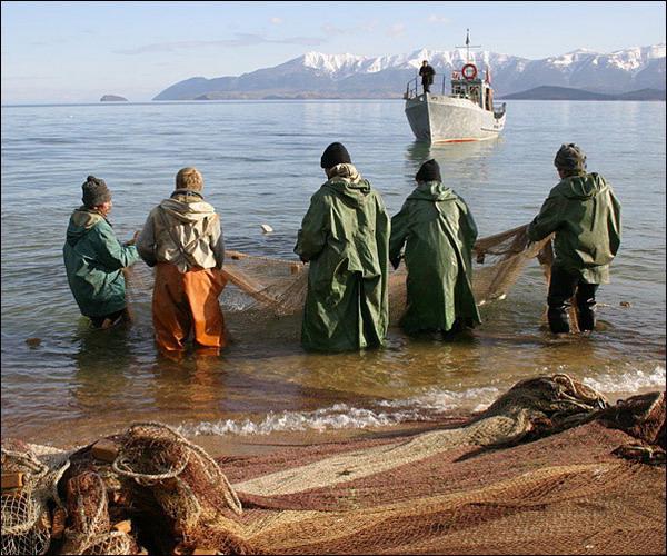
As for the shallow depths of Baikal, many consist of vast areas, especially adjacent to river deltas, of sand or sand mixed with silt. Even closer to the shores, the bottom is covered mainly with stones and more or less large pebbles. Only in a few areas the bottom up to the very shores is made of sand. Such areas have great importance, as convenient for seine fishing.
However, Baikal did not always have those character traits bottom relief and the shape of its outline that it currently has. There is reason to assert the opposite, namely, that Baikal in its modern form was formed, from a geological point of view, relatively recently - at the end of the Tertiary or even at the beginning of the so-called Quaternary time. By this time, by modern views geologists, refers to the formation of the great depths of Baikal, as well as the formation of those mountain ranges that border the lake. There is little information about what the reservoir that was on the site of Baikal before this time was like.
Apparently, it was a complex system of lakes connected by straits and occupying a larger territory than modern Baikal. There is reason to believe that this multi-lake region extended to Transbaikalia, Mongolia and possibly Manchuria and Northern China.
Thus, Baikal in its present state is, to a certain extent, a remnant of reservoirs that once occupied a vast area and have repeatedly undergone significant changes. How could this affect the composition of the animal and flora Baikal, we will look at it below in the corresponding chapter.
During the Ice Age, when powerful glaciers covered large areas in some areas of Siberia, there was no continuous glaciation in the Baikal region, and glaciers descended to the shores of Lake Baikal only in isolated places. Piles of stones and sand, brought by glaciers and called moraines, in northern Baikal in many places descend from the adjacent mountains to Baikal itself, but it can be argued that this ice never completely covered the surface of Baikal.
Moraines left after the Ice Age had a significant influence on the formation of the shores of Northern Baikal. Some capes in the north of Lake Baikal are made of moraine materials, such as Cape Bolsodey. On the eastern shore of Northern Baikal, where many capes are also made of moraine material, they were subject to severe destruction by the surf. Smaller boulders and loose material were washed away by the waves, and large boulders, preserved in the area as underwater rocks dangerous to navigation, are the remains of moraines that were in these places and indicate their much greater distribution in the past than is the case now.
Geologists have made different assumptions about how the Baikal basin with its enormous depths was formed in its modern form.
During the eighteenth and first half of the nineteenth centuries, geologists believed that Baikal was a deep earth's crust resulting from major disaster that took place in this area of the mainland. I.D. Chersky significantly changed these ideas. He considered Baikal not a failure, but a very ancient body of water, preserved from the time of the Silurian Sea and gradually deepening due to the slow and gradual subsidence of the earth's crust.
Later academician V.A. Obruchev returned to the old ideas about the failure and explains the formation of the modern depths of Baikal by the subsidence of the bottom of the graben, which this lake represents. This subsidence occurred simultaneously with the uplift that formed the mountainous country on the coast of Lake Baikal, and apparently continues to this day.
There are other geologists who also connect the formation of Baikal with the arched uplift of the Baikal region and subsidence - the collapse of the central part of this arch, but the time of this uplift, in their opinion, dates back to the second half of the Quaternary period, i.e. to the time of primitive man.
Finally, according to the latest views of E.V. Pavlovsky, the Baikal depressions and the ridges separating them are so-called synclines and anticlines, complicated by faults and developed gradually over many geological epochs, against the background of a general arched uplift of the Stanovoy ridge.
Finally, according to the views of N.V. Dumitrashko, Baikal is a complex system of three basins. The southern one arose during the Upper Jurassic, the middle one - in Tertiary time, the northern one - on the border of Tertiary and Quaternary time. The basins and the surrounding ridges are blocks into which the Baikal region was broken during the last eras of mountain building. The descending blocks turned into basins, and the rising ones - into ridges. We have a whole series of evidence that the formation of the Baikal basin continues to this day, and that the bottom of the basin continues to descend, and its edges in the form of the limiting Baikal depressions of the mountain ranges rise.
 Signs of bank subsidence, villages. Ust-Barguzin in 1932. Photo by G.Yu. Vereshchagina
The subsidence of the shores of Lake Baikal is especially pronounced in places where the basin continues beyond its shores, such as, for example, to the west of the area between Kultuk and Slyudyanka, in the Barguzin Bay, in the area between the Kichera and Verkhnyaya Angara rivers, as well as in areas far beyond Baikal basin delta Selenga. In all these places, not only are there features of the coastline that indicate a gradual subsidence of the shore below the lake level, but there are also evidence confirming this historical facts. So the village of Ust-Barguzin has already changed its location twice, moving away from the shore of Lake Baikal, as the waters of the lake flood the place of its former location. This village is still in a semi-flooded state. A similar phenomenon is observed in the village located at the mouth of the river. Kichery (Nizhneangarsk), where once was the center of the entire region, and now only a small number of houses remain. In the Selenga delta, the subsidence of the area is expressed in the fact that there is a gradual swamping of the meadows of the delta and the transformation of once dry meadows and even fields into a swamp.
But the most significant is the lowering of part of the bank in the river area. Selenga in December 1861, which led to the formation of Proval Bay. Then she disappeared under the waters of Lake Baikal Northern part delta river Selenga, the so-called Tsagan steppe with all the Buryat uluses, hayfields and other lands, with a total area of about 190 square meters. km. This was preceded by an earthquake, and a strong vertical blow was felt, from which the soil on the steppe swelled up in mounds and sand, clay and water were thrown out of the resulting wide cracks. The steppe was flooded with water, gushing out in fountains more than two meters high. And the next day, the water of Baikal flooded the entire subsided space up to the Bortogoy steppe. According to eyewitnesses, water came out of the lake like a wall. In place of the steppe, Proval Bay currently stretches out with depths of up to three meters.
Secondary redistribution of sediment along the coast leads to a number of changes in the nature of the Baikal coastline, of which we will point out only the most important. Thus, the accumulation of these sediments in bays and other bends of the coast leads to their gradual straightening and the formation of shallow, gently sloping shores to the water's edge, made of sand or small pebbles, which are usually good non-water sinks.

The movement of sediment along the coast leads to other phenomena: for example, islands located near the coast are gradually attached to the coast by forming a bridge made of sediment connecting them to the coast. The largest of these bridges on Lake Baikal connects, as already noted, the once rocky island of Svyatoy Nos with the continent, turning it into a peninsula. Typical bridges made of sediment are observed on some capes of the Small Sea, like Kurminsky, which was also once an island and only secondarily attached to the shore by sediment. In the same way, some capes in the Chivyrkuisky Bay are attached to the coast, for example, Cape Monakhov, Cape Katun, etc.
 The advancing coastal rampart near the mouth of the river. Yaksakan (eastern coast of northern Baikal). Photo by L.N. Tyulina
The movement of sediment along the shore also leads to the detachment of its bays from the lake. It is this process that causes the formation of its so-called litters on Lake Baikal. Once upon a time these were just curves of the coast - bays. To the side of these bays along the shores, under the influence of the prevailing direction of the surf, the movement of sediments occurred, which, having reached the bay, were deposited on its bottom in a direction that was a continuation of the general direction of the coast in this area. This is how narrow sandy islands, elongated in the form of strips, arose, with which the sors are gradually separated from Baikal. In some cases, such bridges have already led to the almost complete disconnection of bays from the lake, such as Posolsky Sor. In other cases, this process is not completed, such as the Istoksky litter, or it is just beginning, which is the case in Proval Bay.
In the cases prevailing on Lake Baikal, coastal sediments accumulate weakly near its shores, and as a result, the very shores are exposed to the destructive action of the surf. Some sections of the coast are literally chewed up by the surf. Up to a height of 5 meters or more, the rocks have been destroyed, representing cliffs with an uneven, jagged surface, and in many places niches and caves have been carved into the rocks by the surf.
The destruction is especially severe on the shore of the island facing the Small Sea. Olkhon and, in particular, on the capes of this coast, as well as on the capes of the Olkhon Gate Strait.
The surf can also lead to the complete destruction of islands, as if cutting them off near the water's edge. It is in this state, very close to complete destruction, that the Malye Ushkany Islands are located, of which the long island is currently only a few meters wide.
Completely cut off by the surf of Lake Baikal, apparently, is the island of Stolbovoy, which once was in the middle of Lake Baikal between Goloustnoye and Posolsky and marked on ancient maps, but now its trace has been preserved only in the form of a shoal in this place.
The surf leads to the separation of capes from the continent and their transformation into islands. This is observed in the Small Sea, where the islands of Kharansa and Yedor arose in this way.
Tremendous waves that cause strong surf, as well as the roughness of the lake, in which this wave is repeated very often, causes an exceptionally strong influence of the surf on the shores and leads to both their destruction and the movement of sediments and the formation of shore areas washed up by the lake. Baikal is a classic place for studying the work of a lake on its shores, which has not yet been adequately appreciated in this regard.
Baikal is not only the largest, but also the most mysterious and enigmatic lake on the planet. Many legends and traditions are associated with its appearance, which dates back 35 million years. As soon as it is not called - the pearl of Siberia, mighty water, great fire, sea. Where is Lake Baikal located? The oldest reservoir is freely spread out in the southern part of Eastern Siberia.
Geography
The length of the lake, located at an altitude of 450 meters above sea level, is 636 kilometers, and the coastline stretches for almost 2,000 kilometers. Most of it consists of nature reserves and parks under state protection. The width of Lake Baikal, due to its unusual crescent-shaped shape, reaches 81 km in the central part and 27 km at its narrowest point.
The northwestern part of the huge reservoir is located in the Irkutsk region, the southeastern part is in Buryatia. Assessing the depth of Lake Baikal, which ranks first in the world, experts call the figure 1640 meters with a permissible error of 2%. The second deepest lake is Lake Tanganyika on the African continent, which is two hundred meters behind the leader. More than three hundred rivers and streams replenish the supply of fresh water in the lake, a good half of the total volume comes from the Selenga. But only one flows out of it, the Angara. There are twenty-two islands on the lake, the largest of which is Olkhon.

The map can be enlarged by clicking on it with the left mouse button.
Why is Baikal called Baikal
According to ancient legend, the “oldest” lake on the planet appeared as a result of a volcanic eruption. But researchers are still arguing about the origin of its name. There are several assumptions:
- Bai-Kul - translated from Turkic means “rich lake”;
- Baigal - from the Mongolian “rich fire”;
- Baigal Dalai - in the same Mongolian means “big lake”;
- Beihai - on Chinese means "northern sea";
- Baigal-Nuur is a Buryat name;
- Lamu - that’s what the Evenki called the lake.
It is believed that the first explorers who appeared here in the seventeenth century called Baikal by the Evenk name. Later, having switched to the Buryat name, they softened the letter “g”, giving the name the current appearance.
Waters of Lake Baikal
The purity of the lake water is amazing. Its transparency is 40 meters, and its oxygen saturation and unique composition, slightly mineralized and close to the characteristics of distilled water, make it unusually healing.
During algae blooms, transparency decreases slightly, but remains quite high. Of great interest to tourists is watching a coin thrown into the waters of the lake, which can be seen quite clearly. long time. Visiting the famous lake is the dream of almost every Russian. Where Lake Baikal is located is already known, but what kind of weather prevails there?
Climate
If you look at where Baikal is located on a map of Russia, you can note that it is only 70 kilometers from Irkutsk. However, it is rash to assume that the climate is the same here and there. Typically sharply continental in these places, it is significantly softened in the lake area by the abundance of water and dense forests. Air temperature on Lake Baikal in winter time warmer, and in summer - colder by almost 10 degrees. In addition, rainy weather is rare here. Minor evaporation of water does not contribute to the formation of clouds, and their counterparts coming from behind the mountains heat up and dissipate.

Sometimes, of course, you can get caught in the rain, but the number of sunny days on Olkhon Island, for example, is much greater than on the Riga seaside or in the Caucasian Abastumani. The rather cold water of Lake Baikal warms up to 16-17 degrees in summer, but only close to the shore. At depth, the water temperature in summer is only 4-5 degrees. The period from June 15 to August 15 is considered the most successful for a trip to Baikal - warm and sunny.
Fauna and flora
The flora and fauna of Lake Baikal are unique. The lake serves as a reliable shelter for almost three thousand species of animals and thousands of plants, many of which are found only here. And this despite the fact that, as scientists suggest, more than 20% of the living organisms living in it, from the surface to the maximum depths, are still unknown to science. Grayling, whitefish, taimen, sturgeon, omul, lenok, golomyanka - this is not a complete list of fish species inhabiting the lake. There are about sixty of them in total, which turns fishing on a pond into an extremely exciting and productive activity. There are still heated debates about how the Baikal seal, a purely marine mammal, got to Baikal and comfortably took root here. It is assumed that it came here in the distant times of the Ice Age, moving from the Arctic Ocean along the Angara and Yenisei. Now tens of thousands of animals live here.

How to get to Baikal?
Relaxing on the lake is interesting and attractive all year round, each season has its own positive sides. At first, many are slightly intimidated by the long journey, but having learned how to get to Baikal, they are determined to set off. Every day flights depart from Moscow airports Vnukovo and Domodedovo to Ulan-Ude and Irkutsk. The flight time is almost the same - the plane flies six hours to the first destination, twenty minutes less to the second. Irkutsk airport is located six kilometers from the center.
The journey by rail will take a little longer; the Moscow-Irkutsk train will cover the distance of 5192 km in 3 and a half days. However, magnificent scenery and decent service will help brighten up your travel time. From regional center Getting to Baikal is not difficult - there are minibuses and buses from the central bus station, electric trains and trains from the railway station, and from the Raketa pier in the summer you can go by yacht or boat. A short distance of 70 kilometers will not seem too long and boring.
Listvyanka
At the source of the Angara, the oldest Baikal village of Listvyanka is located, which is about three hundred years old. Previously, local residents lived by hunting and now there is a fairly developed tourist infrastructure with comfortable hotels, inns, cozy restaurants and entertainment venues, saunas and bathhouses with Baikal water. From this settlement acquaintance with the region begins, here is the only Russian Federation Lake Museum. It is invariably visited by domestic and foreign tourists, getting acquainted with the history of the famous reservoir, its flora and fauna, and the results of numerous scientific studies.
The village has many attractions that are worth visiting:
- "mini-zoo" with bears and foxes,
- nerpinarium,
- Art Gallery,
- Shaman-stone,
- observatory.

The diving centers operating in the village offer tourists an unforgettable experience - diving into the clear waters of the unique Lake Baikal to a depth of three to forty meters. This is possible at any time of the year, since the water temperature at the dive sites is from 3 to 12 degrees. In the summer, many water excursions depart from Listvyanka to the nearby village Big cats, to Sandy Bay, to the port of Baikal. You can take the opportunity to ride along the water surface of Lake Baikal on your own, on a rented boat.
Seasonal holidays
The flow of tourists to Baikal does not weaken, but is growing every year. If you look at where Lake Baikal is located on a map of Russia, you can clearly see that it is located in a cozy environment of mountain ranges and forests. The unique beauty of these places is beautiful in its own way at any time of the year.
In winter, lovers of ice fishing, skiing, sailing, and cycling on the thick ice of the reservoir come here. Those who come here at the end of spring will be able to see the majestic awakening from hibernation and the rescue of Baikal from ice captivity. At this time there are not many tourists and you can enjoy unity with nature without interference. In the spring, you can even meet the clubfooted inhabitants of the Baikal-Lena and Barguzinsky nature reserves, who go out to the water. the diversity and riot of colors of the forests close to the lake. However, the end of October and November are characterized by inhospitable weather and possible thaw.

Interesting and mysterious sights of Lake Baikal
- Shaman-stone - according to legend, has miraculous power. The owner of the Angara, Ama Sagaan noyon, lived here, magical shamanic rituals were performed and criminals were left overnight to repent of their deeds and admit their guilt.
- Cape Khoboy on Olkhon Island - a petrified Buryat woman, punished for her envy. There are many legends associated with the cape. In winter, a real delight is visiting the grottoes located here, exquisitely decorated with transparent icicles.
- Shamanka Rock, located on Cape Burkhan, is made of granite, quartz and snow-white marble. The through cave located in it was the center of cult worship of the Buryats, who considered it the residence of the owner of Lake Baikal. The entrance here was closed to mere mortals, and women went around the rock by the farthest road. Various rituals and ceremonies were held in the cave, which evoked sacred awe among the local population. Pagan priests lifted family curses here, relieved illnesses and predicted the future by falling into a trance.

What city is Baikal in?
Having firmly decided on the nearest trip to Lake Baikal, the potential tourist begins to develop a route and asks a completely understandable question - where is the lake located?
- Babushkino;
- Listvyanka;
- Big Cats;
- Pankovka;
- Nizhneangarsk;
- Baykalsk;
- Severobaykalsk and many others.
You can stay with a tent in a campsite, use the services of a well-equipped tourist base, or rent a room in a cozy house from local residents. Also, if all family members are completely independent and are not afraid of hiking difficulties, you can go on foot with backpacks and a tent. independent travel, stopping for the night and rest in the most picturesque places of Lake Baikal. Such a vacation will certainly become the most memorable and significant event in family life.
On the world map, the Baikal “comma” is right in the center of Eurasia. Either it “smiles” at a person’s curiosity, or it means a secret, an understatement. That’s right – the special aura of these places opens up immediately and never lets go. Asia and the East are intertwined here, European civilization has intervened, but there are still more untrodden places here than inhabited ones.
Geographical location and history of the origin of the lake

When asked where Lake Baikal is located, the most common answer is - in Siberia. The lake of tectonic origin lies in a rift cavity - like, for example, the Dead Sea. On the map of Russia, a fresh body of water separates the Irkutsk region and Buryatia. The length from the north to the southwest is almost 640 km, relatively narrow in width - from 25 to 80 km.

Satellite images show the thickness of the water - the maximum depth is 1637 meters: on the map of the planet's hemispheres, there are only 6 lakes deeper than one and a half kilometers, and Baikal takes precedence.
Curious! There are many versions of the origin of the name of the lake, the advantages are in expressions that are consonant with the current pronunciation:
Beihai (Chinese) – northern sea;
Baikol (Turkic) – rich lake;
Baigal-dalai (Mongolian) – rich flame.
Road to the lake

Airports and railway stations are located in Irkutsk and Ulan-Ude. The regularity of flights and express trains is high, prices are suitable for any budget thanks to the active development of the tourism cluster. Depending on the city in which the journey begins - the coast is from 70 to 140 km, regular buses run around the clock.
Features and mysteries of Baikal
Basin
Geologists cannot determine the exact age of the reservoir. Amazing location: Baikal lies as if in a stone vessel, and this makes diagnostics difficult - there is no bottom soil for archaeologists and biologists. So 30 million years or “only” 150 thousand? No answer.
Dark rings

For many years now, the lake surface has been spontaneously covered with huge rings several kilometers in diameter. Observers notice this every spring on the satellite map. Researchers from the Russian Academy of Sciences have put forward a hypothesis that this is how bottom water with gases rises. But ufologists insist on the extraterrestrial origin of this geometry.
Deep space

An unexpected location was chosen for a new super-powerful telescope at the end of the 20th century: Baikal, the bottom pillow. It turned out that it is easier for astrophysicists to pick up signals from space through water. The mystery gave rise to belief in the existence of a deep port for aliens - after winter, traces of “active” flights emerge in the famous “rings”.
Baikal Stonehenge

Bizarre man-made structures are located in a remote area of the Baikal-Lena Nature Reserve. On Cape Rytom, someone in ancient times built a stone fence 333 meters long. Inside there are pyramids made of flat slabs. Eyewitnesses admit: there are no burials there, but the energy is incredible. However, it is almost impossible for neophytes to get here.
Underwater riddles
In the great depths of Lake Baikal, they are looking for secrets and treasures, scrupulously calculating coordinates: Baikal is historically associated with the Supreme Ruler Kolchak and the missing tons of gold reserves. Suddenly hidden at the bottom?.. The great director J. Cameron equipped an entire expedition to the bottom of Lake Baikal. What discoveries he made remained a secret.
Living water

Environmentalists praise the life-giving composition of the lake cocktail. Despite active industrial intervention, the purity of the lake is unique: mineralized, saturated with oxygen. Even under a meter of ice, the bottom stones are clearly visible. The recipes are known - crustaceans and sponges can do it. Using these properties in cities is a challenge.
Flora and fauna of Lake Baikal
Flora of Baikal

No other region has such a unique combination of natural and climatic zones. Along the entire perimeter of the Siberian Sea there is a wonderful variety of vegetation - from arctic to subtropical species. Hundreds of rare shrubs and conifers grow here, rhododendrons and edelweiss bloom. The favorites are:
Relic forest– living “fossils” have been preserved on Olkhon since Paleolithic times.

Oaks and hornbeams– the groves on the southeastern coast are like an oasis in the center of Siberia.

Blue spruce– an unusual decorative shade is created by the waxy “cover” of the needles; the region of origin of the species is unknown.

Fauna of Baikal
The water area and shores of Lake Baikal are famous for their biodiversity. Scientists are surprised - what a rich region: more than 1,500 species - ancient deep ciliates, a host of insects, fish, birds. The coastal zones, abundant in food, are favored by predators and herbivores: bears, wolverines, and deer. The fresh sea also has its own legendary inhabitants:

– the fur-bearing animal lives in cedar trees along the entire eastern coast along the Barguzinsky ridge. Omnivorous, due to the value of fur it was on the verge of extinction, until physical map the area did not become the first nature reserve in Russia - it already has a 100-year history.

– Baikal seal, protected by the state. There are many versions of how a marine mammal found its way deep into the continent into a fresh lake. Some are sure that from the Arctic along the Yenisei and Angara, others believe in more exotic versions. Good-natured longhorned beetles weighing up to 170 kg stoically endure hordes of tourists.

– a fish from the whitefish family, considered a signature delicacy, weighing from 0.5 kg to 5 kg. Commercial mining is underway.

Curious! The crustaceans Epishura baikalensis, copepods of cleaners, have been working for millions of years: they have successfully coped with biopollutants. But modern chemical runoff threatens this population and the lake’s ecosystem.
Sights of Baikal

Lake Baikal on the world map is an object of attraction in itself. Pagan myths are still alive here - and every cape, bay, and rock is covered in them. The legends of the Golden Horde are revered, the Old Believer villages of the first Russian settlers and ancient Buddhist datsans stand as a source of wisdom. Hundreds of natural and historical monuments. First of all, you should look at:

Circum-Baikal Railway– built as part of the Trans-Siberian Railway; now 89 km along the coast, through tunnels and stone galleries with amazing views.

Shaman-rock on Cape Khuzhir - the ridge of the sacred mountain crashes into the water: rituals have been performed here for thousands of years, and as a sign of continuity there are 13 ritual serges, visible from afar.

Cave Dream– we didn’t exactly count how many kilometers in length – but it is the deepest, with golden stalactites, it impresses with a fabulous view and a special musicality of sounds.

Olkhon- an island in the middle of the water, with a spruce forest of prehistoric times and the stunning beauty of the panoramas.

Taltsy– ethno-village-museum of life of the indigenous population of the Baikal region: authentic and impressive.
The largest natural freshwater reservoir is located in Russia, in Eastern Siberia. Its shores and waters belong to the Irkutsk region and the Republic of Buryatia.
The most convenient way to get to Lake Baikal is from Irkutsk - there are many types of transport and only 70 km to the lake. Ulan-Ude is located much further away, and there are much fewer communication options.
The climatic zone in which Baikal is located is a temperate zone, however, due to its amazing and unique shape, bottom topography and coastline, the deepest lake on the planet is divided into three separate parts - Southern, Middle and Northern. Moreover, each of these zones has its own natural and climatic features, each is characterized by unique flora and.
The beauty of Baikal, the special energy of this place, the unique flora and fauna, as well as the opportunity to engage in diving, hunting, fishing, photography, etc., attract millions of tourists from all over the world.
The length of Baikal from north to south is almost 600 km, and the maximum depth of the reservoir is 1620 m. This is the deepest lake on planet Earth.
There are two main ways to get to the lake: by plane or by rail. By air you can fly from almost any major airport Russia (Moscow, St. Petersburg, Yekaterinburg, Novosibirsk, Kazan, Vladivostok, etc.) and arrive in Irkutsk or Ulan-Ude by direct flight or with a transfer.
It’s similar with railway transport: from almost any corner of Russia, regardless of the significance and size of a city or town, you can directly or by way of transport to the administrative centers of the Irkutsk region or the Republic of Buryatia.
It is noteworthy that in Africa there is a “twin brother” of Lake Baikal - Lake Tanganyika. It is also distinguished by its unique ecosystem; it has a similar shape to its Siberian counterpart, only its semicircle is turned in the opposite direction.
The distance from Moscow to Irkutsk by rail is almost 5,200 km. A high-speed train overcomes it in 3.5-4 days.
Both Ulan-Ude and Irkutsk are located several tens of kilometers from Lake Baikal, and from these cities you can get to the lake by taxi, electric trains and trains, minibus or bus. In the summer, yachts and motor ships go to the lake from Irkutsk, from the Raketa pier.
What is Lake Baikal like? Where is? Surely many travelers have asked this question, trying to refresh their memory of their school knowledge. Baikal is considered the largest fresh water reservoir on the planet. By age, depth and reserves drinking water he simply has no competitors.
So, Baikal! There are legends about it as a formidable and angry lake. Various epithets are awarded to the famous reservoir: “the blue eye of Siberia”, “the sacred gift of nature”, “the world’s source of drinking water”.
Baikal. Where is the lake?
The lake is located in the south of Eastern Siberia. This is on the border of Buryatia on the Asian continent. Now do you remember where Lake Baikal is? A photo of the famous lake will help everyone imagine the Siberian beauty of the reservoir. Scientists have recorded the water surface area of Lake Baikal as 31,722 square kilometers. This figure can be equated to the area of Belgium or the Netherlands. The width of the mysterious reservoir reaches 79 kilometers. The length of Baikal is 620 kilometers. From a bird's eye view, the lake looks like a giant crescent. Baikal is the deepest lake. According to scientific research data, its maximum depth is 1642 meters.
No one can definitely answer the question of where the name Baikal itself came from. Much has been devoted to this topic scientific works and literary publications. But not a single scientist was able to provide categorical evidence regarding at least one theoretical guess.
Where Baikal is located, beliefs and legends live. In the past, the peoples living near Baikal called the lake in their own way: “big reservoir” or “rich water”. If we take into account the age of the reservoir, then, according to scientific research data, Baikal was formed more than 20 million years ago.
Typically, ice age lakes live for about 15 thousand years, and then gradually disappear from the face of the earth. However, Baikal shows no signs of aging. According to research recent years, geophysicists have suggested that Baikal may well be an incipient ocean.
Miscellaneous
The Baikal pit is recognized as the cleanest reservoir of drinking water on the planet. The lake is incredibly clean and rich in oxygen. Experts believe that this water is close in properties to distilled water. Previously, Baikal water was used for treatment. Lake Baikal contains a huge variety of living forms. These are fish: the famous omul, whitefish, the perch and salmon families. Which of the fauna can still be found in the area where the lake is located? Baikal?

Baikal seals and noisy seagulls live on the coast. Sometimes there are brown bears emerging from forest areas. Scientists count about 847 species of fauna and approximately 133 species of various plants in the nature of Baikal.
Thanks to such diversity, an increasing number of tourists are coming to this amazing place to breathe a breath of fresh Baikal oxygen. Every year on Lake Baikal there is intensive development infrastructure. This encourages everyone who has been here to visit the proposed recreation area many times.
Where to stay on Baikal? Various hotels, sanatoriums, and tour operators are available to vacationers. All conditions are created so that the traveler can improve his physical and spiritual health. For many years, the thermal and mud springs of Goryachinsky, Zmeevoy, and Khakusy have been famous for their healing properties.
All of these natural sources are of great help to a person in the treatment of blood circulation, nervous system And skin diseases. The most popular source is Zmeinaya Bay. Despite the lack of amenities, the number of people coming here is constantly growing.
Baikal can tear a person away from his usual civilization, amaze him with its landscapes and fill him with life-giving energy! Of course, having come to Lake Baikal once, it is impossible to study all the local culture. To begin with, use the services of guides or plan excursions in advance.
Think about what you will travel on: a bicycle, a car or an ATV? And if you are an excellent rider, then the horse - great companion for such trips. If the question arises about what time of year is the cheapest to relax on Lake Baikal, then you should go in September. It was during this period that prices for sanatoriums and tour operator services were significantly reduced.
Baikal. Where is the place that can cause excitement among the male part of the population? This is a fishing zone! This type of entertainment delights all fans of this exciting activity. On the territory of Lake Baikal there is a great opportunity to allow everyone to show their fishing skills. The most popular places for this are Chivyrkuisky Bay, Maloye More, Proval Bay and Lake Baikal itself.
There is indeed an abundance of fish in these water areas, but catching them is not an easy task. Some tourists even have to resort to the services of instructors. But it's okay!
Just practice and you'll be on your way! Most likely, friends, looking at photos on this topic, will ask: “Where are you?” After a short pause, you will probably give a proud answer: “Like where? Lake Baikal!”
Winter fishing has its advantages. It is no less exciting than in the warm season: there are fewer people, so there is peace and a sense of freedom.
Holidays on the famous Lake Baikal are quite varied. If you are dreaming of swimming, summer fishing and other entertainment during the hot season, then it is more advisable to go on vacation in July-August. At the beginning of summer, Lake Baikal is still cold and the water is not warmed up enough. And in the northern part of the reservoir there are even floating ice floes. The end of August can ruin travelers' time with gusty winds. During this period, the water mixes and its temperature drops. But for those travelers looking for solitude in nature, autumn is a wonderful time of year. The local coastal vegetation is painted in bright colors, forcing tourists to preserve this beauty in the photo.
Where to relax on Baikal?
If you know what you expect from this trip, it will be easier to decide on a vacation spot. For those who prefer the thick of the masses, the roar of various music and the roar of jet skis, the western coast of Olkhon Island, Peschanaya Bay, the coast of the Small Sea, the coast from the village of Baikalskoye to the city of Severobaikalsk, and the Circum-Baikal Railway are suitable.
A cruise on the Circum-Baikal Railway is a win-win option have an interesting holiday. Typically the excursion lasts 2 days by train. On this trip, the guide will tell travelers about the famous places of Lake Baikal. There are short stops at noteworthy places. Therefore, you can contemplate nature in these parts to your heart’s content.
The places where Baikal is located offer everyone the comfort of tourist centers and sanatoriums of Southern Baikal (Utulik, Electra, Angara and others). This should save the vacationer from questions about where to live on Lake Baikal. Maloe More is located a little secluded, and accommodation here is possible in a yurt at affordable prices. Olkhon Island is located in an inaccessible place. You can only get to it on foot or by water. This is an excellent relaxation area for those who are tired of the city noise and bustle.
You can diversify your time at the deepest reservoir by taking part in a cruise on a boat or yacht. This way you can visit the wild shores of Lake Baikal. Group excursion routes are known. They are notable for the fact that vacationers can visit the most unusual corners of the Baikal region.
If a tourist has a desire to use the vacation for the purpose of recovery physical health, then he can resort to the services of hot springs in the north of the lake. Active travelers will enthusiastically embrace hiking and horseback riding, as well as exciting rafting along mountain rivers. Fans of winter recreation can organize walks along the Baikal ice skating rink, ride snowmobiles or dog sleds. For fans of alpine skiing, the tourist base “Mount Sobolinaya” is active from December to May.
Holidays on Lake Baikal as a savage

On Baikal? And How? Rest as a savage is the most freedom-loving. For those who love adventure, Lake Baikal is a real find! The most suitable place for such a pastime is Peschanaya Bay. Only here a real tourist feels an absolute separation from civilization - there is no communication, no roads.
Only private yachts and the motor ship "Barguzin" go here, departing from the Irkutsk pier. Accommodation for vacationers is provided small houses or tents. This island has pristine nature. It is so alluring that it literally bewitches tourists, forcing them to return here again and again.
A tourist center that can offer interesting excursions is at the service of savage travelers. Where to relax on Lake Baikal as a savage? The magnificent island of Olkhon is ready to welcome a wanderer! It can charm every person with the harmony of its forests and steppes. Olkhon is an unforgettable fishing experience and a lot of positive emotions.
Mysterious rock
This island is interesting as a place of shamans. There are opinions that the grave of Genghis Khan is located there. Some local residents still worship spirits today. Old-timers can tell travelers a lot about the mysterious Shaman Rock.

It is the highlight of Lake Baikal. Researchers of this area claim that in ancient times the Buryats brought a huge number of sacrifices to the rock. There are many legends on this topic. One of them says that Ezhin, the owner of the island, lives on the Shaman Rock cape. Until now, local residents treat this place with due respect.
Among the tourists there are a few brave souls who are ready to approach Shaman Mountain. According to legends, this place is endowed with special energy powers. The photographs leave as a souvenir for travelers the drawings of shamanic drums carved into the rock by ancient people. Unfortunately, these images have been partially destroyed due to the intervention of the human hand in an attempt to extract the marble.
Sights of Irkutsk

In those places where Lake Baikal is located, the city of Irkutsk is the most unknown and underrated in the world of tourists. Many Russians have vague ideas about this holiday destination. It's a pity!
Foreign tourists explore the sights of Irkutsk with undisguised interest. After all, this is a treasure trove of natural and man-made works. Architecture connoisseurs enjoy visiting the Church of the Exaltation of the Cross.
After all, its structure is unique: the temple fences and crosses are made according to the old pattern of blacksmith work. Another famous attraction of Irkutsk is the Taltsy architectural and ethnographic museum. It is located in the open air and houses real masterpieces of architecture!
Tourists who come here can witness Orthodox holidays: in winter - Christmas and Maslenitsa, in summer - Trinity. In the winter season, residents of Irkutsk build snow towns, ski ice slides on cow skins! Agree that this forgotten vacation can bring real pleasure to every traveler.
After such festivities, you can enjoy hot dishes of original Russian cuisine: hot pancakes, meat goulash, Siberian dumplings! Along with this, everyone can taste Japanese and Chinese dishes in cafes, bars and restaurants at reasonable prices.
Extreme holiday

So, you have arrived to Baikal! Where is the place that will give the traveler drive? What else will captivate this famous territory for a vacationer? Baikal is capable of providing the traveler with an extreme type of recreation that can cause him a special surge of emotions and adrenaline. This is especially facilitated by dynamic rafting along the mountain rivers of Lake Baikal. Such water travel is notable for the fact that after such a trip the tourist is no longer indifferent to this type of recreation.
Worth seeing at least once wildlife Siberian taiga, rafting down a stormy river with a group of comrades. Memories of the euphoria of such a hike will accompany you for many years. So, let us remember that mountain rivers originate in the upper reaches of the mountain. River layers of water from there rush down to the plateaus and plains. Because of sharp changes At altitudes, the flow speed of mountain rivers ranges from 25 to 30 kilometers per hour. The number of obstacles encountered in the path of the current (rocks, waterfalls) determines the category of difficulty of water rafting.
The first category includes calm water, to the sixth - obstacles with waterfalls and rapids reaching up to 15 meters. Tourists can conquer such mountain rivers on rafts. This is the most popular vessel for this extreme type of recreation. It looks like an inflatable boat. Its bottom contains holes to drain water that gets inside the boat.
A raft differs from ordinary inflatable boats in that its design is reinforced with a durable shell, special fastenings for travelers’ legs and double-layer cylinders. The raft is used when passing water obstacles of 1-5 difficulty categories.
To get more intense emotions when passing river rapids, tourists use a catamaran. These are two inflatable cylinders made of very durable material, which are interconnected by an aluminum partition. A catamaran on the water is well stable and gives a stronger sensation than a raft.
To control a catamaran, more precise actions are required. It usually accommodates 2-4 people. With such a device it is possible to pass water obstacles from 1 to 6 categories of difficulty.
If you are wondering where to visit Lake Baikal, then you should take a hike to the top of Mount Munku - Sardyk. Such a trip can become unforgettable, since this place is considered the highest point in Eastern Siberia. Tourists who reach the snow-white peak will enjoy stunning views of the lakes frozen under the ice. At this moment it will seem simply incredible! The best time to enjoy such beauty is April and May.
Tourists who have been to Lake Baikal more than once note that, most likely, this trip will change a beginner. The mystery of this Siberian place can touch the subtle strings of a person’s soul, awakening in him a sense of novelty and harmony.